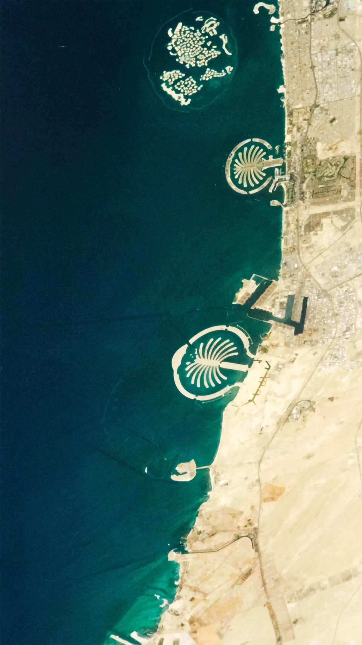
Dubai has some of the largest and most eye-catching reclamation projects on earth along its coastline. No other coastline on earth can be compared with the coastline of Dubai. Just two decades ago, there was nothing to note on the city's coastline except the shallow waters of the Persian Gulf. Today, the coastline is home to some of the largest and most eye-catching reclamation projects in the world.
In this photo taken by astronauts of the international space station on April 6, 2022, a pair of palm shaped islands (Palm Jumeira and palm Jebel Ali) surrounded by a circular storm barrier and an archipelago designed as a map of the earth's continent are particularly striking. In order to build these unusual coastal landforms, workers dug sand and silt from the seabed, sprayed them into the desired shape with ships and GPS positioning technology, and used a construction equipment called vibroflot to mix stones to stabilize the new reclaimed islands.

In the 1990s, when developers first made plans for the construction of the Dubai coastline, they had great dreams. This archipelago in the earth's land distribution shape is called the "world Archipelago", including 300 small sand islands, which will be sold to luxury developers and filled with hotels and luxury houses. The original plan was not to have only two Palm Islands, but to build a third (Palm Deira), which would be larger. There is also a plan for a vast archipelago called the universe, including islands designed to be part of the solar system and the Milky Way galaxy.
However, the global recession of 2007 and 2008 delayed and weakened their ambitions. With the decline of financial markets, the plan to promote the universe has been shelved. The ambition of the palm island of Dila has also been greatly reduced. It is now called the Dila islands, while most of the palm island of Jebel Ali is still undeveloped.
Although the islands have been built, only a few of the 300 islands in the "world" have been built. One exception is a new resort on Clarence island in the "South American" part of the islands. Another project is located on six islands in the "Europe" part and is close to opening.
As developers strive to fund and complete projects, scientists are using satellites to monitor a range of environmental impacts and changes related to new landscapes. For example, an international research group pointed out in a paper in february2022 that significant changes have taken place in the water quality around Jumeirah palm island. They report that since 2001, suspended sediment and chlorophyll have gradually increased, and the average water temperature has also increased by 7.5 degrees Celsius (13.5 degrees Fahrenheit). They saw some temporary improvement in water quality in 2020, when the tourism industry on the island fell sharply due to the covid-19 pandemic.
The researchers' findings were based on data collected by Landsat 7 and Landsat 8.