According to the Central Meteorological Observatory, from today to the weekend of May 10, a strong cold air will affect most parts of central and eastern China, and 20 provinces, autonomous regions and cities will cool to varying degrees. Although the solar term has passed the beginning of summer, the cold air and rainfall have been continuous recently, and the temperature has also fluctuated. At 6:00 on May 10, the Central Meteorological Observatory released the forecast of strong wind and cooling:
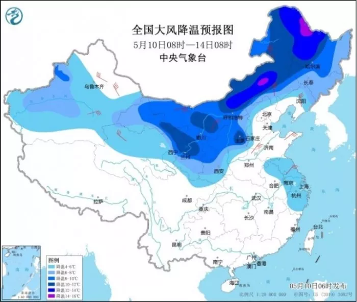
From 8:00 on May 10 to 8:00 on May 14, there will be a strong cold air activity in northern China. The temperature will drop by 4 ~ 8 ℃ in most parts of Northeast China, Inner Mongolia, northern and western North China, Eastern and Northern Northwest China, most parts of Xinjiang, southern Huanghuai, Jianghuai and Eastern Jiangnan
Among them, the temperature drop in some areas can reach more than 10 ℃ in the northeast of Northwest China, the west of North China, the Middle East of Inner Mongolia and the middle and north of Northeast China
Some of the above areas are accompanied by strong winds of force 4 ~ 6 and gusts of force 7 ~ 9.
Among them, from 8:00 on May 10 to 8:00 on May 11, some areas in Northeast and central Inner Mongolia, southern Heilongjiang, central Liaoning and northern Hebei had grade 4 ~ 6 winds;
From 8:00 on May 11 to 8:00 on May 12, there were winds of force 5 ~ 6 in some areas along the northeast coast of Zhejiang, northwest Inner Mongolia and Nanjiang basin of Xinjiang;
From 8:00 on May 12 to 8:00 on May 13, there were winds of force 5 ~ 6 in some areas of Central Shanxi, Northern Henan and Northern Zhejiang.
According to Shi Yan, a meteorological analyst at China weather.com, with the frequent impact of cold air recently, there are more clouds in the sky, resulting in a decrease in the warming of radiation absorbed by the ground. Cold weather is rare in May in some places in North China and Huanghuai river**
Before and after the 12th, the temperature in the above areas will reach the lowest point of this cooling process. The temperature will be significantly lower than that in the same period of the year. The body feeling will directly cross back to the end of March
Among the provincial capital cities, Yinchuan and Taiyuan have the strongest cooling. Today, the maximum temperature is still about 26 ℃, and the day after tomorrow will be in the early 10 ℃, with a cooling range of about 16 ℃.
The maximum temperature in Harbin, Changchun, Shenyang and Hohhot will also drop to around 15 ℃.
From the 15th to the 16th, the temperature in all parts of the South hit the bottom. The maximum temperature in Jiangnan and South China will drop to about 20 ℃, and even only 15 ℃ in some areas. For example, the maximum temperature in Hangzhou and Changsha on the 15th is 15 ℃, which is also the level at the end of March.

In addition, the Central Meteorological Observatory continued to issue a blue rainstorm warning at 10:00 on May 10:
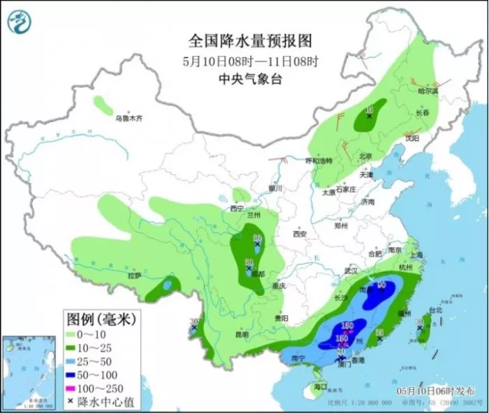
It is estimated that from 14:00 on May 10 to 14:00 on May 11, there will be heavy rain in some areas of eastern and southern Guangxi, most of Guangdong, central and southern Jiangxi and Western Fujian, among which there will be heavy rain (100 ~ 180 mm) in northern Guangdong and coastal areas in the West**
Some of the above areas are accompanied by short-term heavy rainfall (the maximum hourly rainfall is 20 ~ 50mm, which can exceed 60mm locally), and there are thunderstorm, gale and other strong convective weather locally
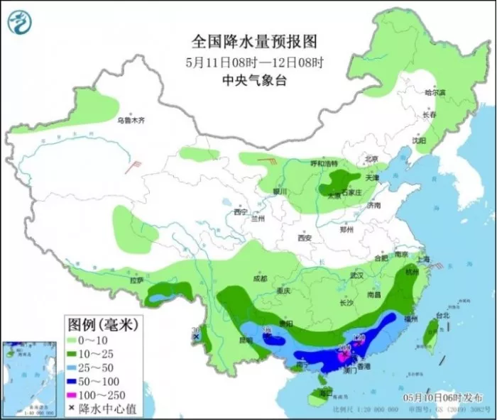
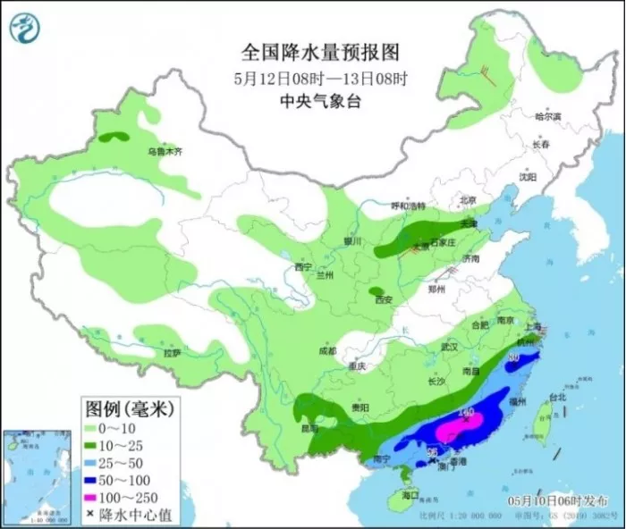
The Central Meteorological Observatory predicts that from the 10th to the 13th, there will be heavy rain in Jiangnan, South China, Guizhou, Yunnan and other places, heavy rain in some areas such as southern Jiangnan and central and western South China, and accumulated rainfall in central and Northern Guangxi, central and northern Guangdong and coastal areas, Southern Fujian and southern Jiangxi may reach 300 ~ 500 mm.
The strongest period of the process is from 10 to 12 days.


